Why Offshore Wind
The U.S. Department of Energy (DOE) and Department of the Interior (DOI) released a National Offshore Wind Strategy document in September 2016 which indicates that 80% of U.S. electricity demands are located in coastal states and that the total U.S. offshore wind energy potential is more than twice what the entire country currently uses. Nearly 80% of the U.S. offshore wind resource is located in deepwater.
Since proven through the New England Aqua Ventus I demonstration project, the University of Maine’s VolturnUS technology could be used to harness the deepwater offshore wind resource within the United States.
Benefits of Offshore Wind
– Start a new industry; create jobs in engineering, construction, manufacturing, maintenance, navigation, and other areas.
– Reduce Maine’s reliance on imported fossil fuels (nearly $6 billion per year); keep more of our energy dollars in Maine.
For more than 10 years, UMaine has led the development of the patented VolturnUS floating concrete hull technology that can support wind turbines in water depths of 150 feet or more and has the potential to significantly reduce the cost of offshore wind.
States to the south of us are working to build their offshore wind industries: MA, RI, NY, and MD have major projects in the works attracting billions of dollars in local investments.
Benefits to Maine
University of Maine Economist Todd Gabe estimates that the New England Aqua Ventus I project will produce nearly $200 million in total economic output, and more than 1,500 Maine-based jobs, including jobs for construction and operations, and maintenance. Full Economic Analysis
Successfully harnessing offshore wind will contribute to the transformation of Maine’s energy sector to renewable sources, and keep our energy dollars in our state.
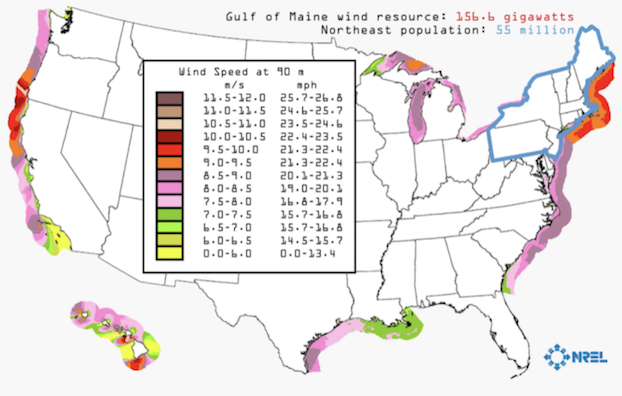
In Maine, offshore wind energy represents our largest untapped natural energy resource, with more than 156 GW (1 gigawatt =1,000 megawatts) of clean power off our coast thanks to the Gulf of Maine’s high-quality offshore wind resource. Mainers currently use 2.4 GW of electricity each year and New England population centers with high electrical demand are nearby. Tapping this renewable resource could provide significant, locally produced energy for Maine and the region.
Maine has the deepest waters near its shores, approximately 200 feet deep at 3 nautical miles, and 89% of Maine’s 156 GW offshore wind resource is in deep waters. The state also offers extensive maritime industry infrastructure and proximity to one of the largest energy markets in the country. Maine is an ideal state to lead deepwater offshore wind development.
NEAV Testing Site, Environmental Impacts, and More
UMaine Deepwater Offshore Wind Test Site
The test site south of Monhegan Island was selected following an extensive public outreach process conducted by the State of Maine due to its distance from the mainland, strong and consistent winds, limited number of fishermen, and close proximity to an island with high energy costs. More than five years of ecological and environmental surveys have been conducted, making the test site one of the most extensively studied locations in the Gulf of Maine. Any future commercial-scale projects involving UMaine’s VolturnUS technology will be sited at least 10 miles from any island, peninsula, or mainland.
Deepwater Offshore Wind Test Site at Monhegan Island.
5+ Years of Baseline Ecological Data Established
The University, State of Maine, and U.S. Department of Energy have funded multiple studies/surveys to characterize the baseline physical and ecological environment of the test site. The University of Maine closely monitored bird and bat activity at the test site from 2010 to 2014. Completed studies include partnering with the New Jersey Audubon Society to use radar to track birds and bats, vessel-based visual surveys conducted by Lubird Environmental, acoustic bat surveys conducted by Stantec, and a passive acoustic survey for songbirds at Lobster Cove, Monhegan Island, conducted by the University of Maine.
Completed Test Site Studies
How will environmental impacts be assessed?
New England Aqua Ventus I is a two turbine demonstration project that requires extensive and ongoing collaboration with state regulatory agencies including: Maine Department of Environmental Protection and Maine Department of Marine Resources, U.S. Fish and Wildlife, NOAA, U.S. Army Corps of Engineers, U.S. Coast Guard, and others.
The University of Maine, the State of Maine, and U.S. Department of Energy have funded multiple studies/surveys to characterize the baseline physical and ecological environment of the test site. Completed studies include partnering with the New Jersey Audubon Society to use radar to track birds and bats, vessel-based visual surveys conducted by Lubird Environmental, acoustic bat surveys conducted by Stantec, and a passive acoustic survey for songbirds at Lobster Cove, Monhegan Island, conducted by the University of Maine.
Ongoing ecological monitoring will be performed during operation for research and compliance.
Proving Maine-made Clean Energy Technology at Full Scale
Maine Aqua Ventus I, GP, LLC, is leading a demonstration project called New England Aqua Ventus I, an 11 MW floating offshore wind demonstration project to develop a renewable energy source off Maine’s shores. Project participants include Cianbro Corporation and the University of Maine.

Maine Aqua Ventus I, GP, LLC, is leading a demonstration project called New England Aqua Ventus I, an 11 MW floating offshore wind demonstration project to develop a renewable energy source off Maine’s shores. Project participants include Cianbro Corporation and the University of Maine.
This demonstration project will deploy a 11 MW turbine on VolturnUS, the floating concrete semi-submersible hull designed by UMaine, south of Monhegan Island, off the coast of Maine. The floating hull/turbine is held in position in the ocean by three marine mooring lines securely anchored to the seabed, with the electrical generation connected by subsea cable to the Maine power grid on shore.
The floating offshore wind turbine platform and column segments will be fabricated and assembled at an existing industrial facility adjacent to the Penobscot River in Brewer. Turbine components will be assembled on the hull in Searsport and subsequently towed to the UMaine Deepwater Offshore Wind Test Site at Monhegan Island.
An interconnection alternate current (AC) cable will join the turbines, and then connect to a 34.5 kilovolt (kV) subsea power cable extending from the test site to a proposed onshore transition point. Several routes to the mainland are currently being evaluated.
Once installed, the turbines are expected to produce clean renewable energy for the duration of a 20-year power purchase agreement (PPA).
Where will construction take place?
The floating offshore wind turbine platforms and column segments will be fabricated and assembled at an existing industrial facility adjacent to the Penobscot River in Brewer. Turbine components will be assembled on the hull in Searsport and subsequently towed to the UMaine Deepwater Offshore Wind Test Site at Monhegan Island.
An interconnection alternate current (AC) cable will join the turbine, and then connect to a 34.5 kilovolt (kV) subsea power cable extending from the test site to an onshore transition point.
What comes after New England Aqua Ventus I?
Successful demonstration of the technology has the potential to lead to a commercial-scale project placed in U.S. federal waters.
Aqua Ventus
What are the project goals?
The goals of New England Aqua Ventus I are to:- Demonstrate UMaine’s VolturnUS at full scale, allowing floating farms to be built out-of-sight across the U.S. and the world in the 2020s and beyond
- Work with local contractors and manufacturers to perfect construction of the floating concrete hull and generate local jobs and economic benefit
- Create and keep Maine jobs in Maine
- Provide low-cost, clean, renewable energy now and in the future that competes favorably with other forms of electricity generation without subsidies.
What comes after New England Aqua Ventus I?
The Aqua Ventus project is designed to meet the objectives of the Ocean Energy Act and Maine legislation to yield tangible economic benefits for Maine, and to lead to even larger-scale, more cost-effective offshore wind developments in Maine and markets worldwide. In November 2020, the State of Maine announced its intention to pursue a research array. The research array will be one of the first pre-commercial scale (50-200MW) floating offshore wind projects in the world and will highlight Maine’s capability and potential. Compared with other floating technologies now being used globally, the UMaine technology has a high readiness level and is in a good position to create market opportunities around the world. The research array will allow Maine to conduct further research on its use and address critical questions – such as on fishing to environmental impacts – prior to potential commercial development. The research array will also generate clean, renewable energy to aid Maine in achieving our clean energy requirements and will help position Maine well to serve a global market. More information about the research array is available on the State’s website: https://www.maine.gov/energy/offshorewind/projects/researcharray/FAQs Aqua Ventus is committed to:- Frequent and transparent outreach with communities and existing marine users
- A single turbine demonstration project within the University of Maine Deepwater Offshore Wind Test Site at Monhegan Island for evaluating technology, monitoring the environment, and developing best practices for coexistence with marine users
- An emphasis on local economic development opportunities
- Future use of UMaine’s VolturnUS floating technology only in commercial projects located more than 10 miles from Monhegan, other inhabited Maine islands, and the mainland coast
- Aqua Ventus is committed to responsible offshore wind development in a manner that includes involvement and guidance by local communities and marine users
Why offshore wind?
The U.S. Department of Energy (DOE) and Department of the Interior (DOI) released a National Offshore Wind Strategy document in September 2016 which indicates that 80% of U.S. electricity demands are located in coastal states, and that the total U.S. offshore wind energy potential is more than twice what the entire country currently uses. Nearly 80% of the U.S. offshore wind resource is located in deepwater. Offshore wind development will:- Create new jobs for Mainers. (Gabe, 2013)
- Minimize viewshed issues
- Place renewable energy generation closer to major U.S. population centers.
- Allow access stronger and more consistent winds.
Will a bond be posted for project removal?
Yes, a bond will be posted to fund project removal as required by state permitting. As required by state law to acquire permits for the research project, funds will be set aside to remove the hull and cable within 60 days after the end of the test program, or in the event of adverse effects on the environment as determined by the Maine Department of Environmental Protection. LD 1465, the State statute governing the use of the test site has specific requirements for project removal, Subsection G. page 6., includes the following: “G. A project removal plan that the applicant will, at its expense, initiate within 60 days of termination of a general permit granted pursuant to this section and that provides for: (1) Removal of the project in its entirety from all project lands and waters, except for any part of the project regarding which the applicant provides the department substantial evidence of plans for continued beneficial use, including but not limited to an executed lease of state-owned submerged lands, as applicable, or for partial removal or other modification adequate to avoid foreseeable adverse effects on natural resources and existing uses; (2) Minimizing seabed disturbances and suspended sediments during removal of any underwater facilities; (3) Monitoring the effects of the removal activities on species listed as threatened or endangered species in Title 12, section 6975 or Title 12, section 12803, subsection 3 and marine resources both during and subsequent to completion of removal activities; (4) An implementation schedule that provides for all removal and restoration activities to be completed within one year of the expiration date of the general permit pursuant to subsection 9; (5) An estimate of the total project removal cost, without regard to salvage value of the equipment, and the net project removal cost, prepared by a licensed professional engineer; and (6) Written evidence and certification that the applicant has posted and will maintain funds for project removal in an amount equal to the net project removal cost, except that at no point may such funds be less than 25% of the total project removal cost. The applicant shall post and maintain project removal funds with a bonding company or federal-chartered or state-chartered lending institution that is authorized to do business in the State and chosen by the applicant and considered acceptable by the department posting the financial security. Project removal funds may be in the form of a performance bond, surety bond, letter of credit, corporate guarantee or other form of financial assurance that the department considers adequate to ensure funds posted pursuant to this paragraph will remain inviolate and available for project removal if the applicant ceases to exist, declares bankruptcy or becomes insolvent or otherwise unable to finance the project removal plan required under this paragraph.”What are the assurances that there will not be additional turbines added to the project of Monhegan?
We are committed to an 11 MW demonstration project within the University of Maine Deepwater Offshore Wind Test Site at Monhegan Island for evaluating technology, monitoring the environment, and developing best practices for coexistence with marine users. Test site usage is limited by state law LD 1465 to a maximum of 2 wind turbines, 3 meteorological towers per wind turbine, one submerged utility line with up to 25 MW capacity, up to 2 wave energy converters, and an ocean sensor package. More information about this law and the permitting process for the test site can be accessed at: https://umaine.edu/offshorewindtestsite/using-test-site/. In the Monhegan Community Benefit Agreement, approved by Monhegan voters on November 2, 2017, Aqua Ventus has committed to build no commercial projects within 15 miles of Monhegan. In addition, the University of Maine has agreed to not allow the use of UMaine’s VolturnUS floating technology within 15 miles from Monhegan, or allow the use of the technology within 10 miles of other inhabited Maine islands, and the mainland coast. UMaine published this commitment in early 2017.Why should Maine pursue offshore wind energy?
In Maine, offshore wind energy represents our largest untapped natural energy resource, with more than 156 GW (1 gigawatt =1,000 megawatts) of potential energy waiting to be harnessed off the coast of Maine. The Gulf of Maine boasts a higher quality offshore wind resource than most parts of the U.S. Mainers currently use 2.4 GW (2,400 megawatts) of electricity each year, however, the Gulf of Maine is located very close to New England populations centers with high electrical demand. In 2008, Governor John Baldacci established Maine Ocean Energy Task Force to recommend a strategy to develop the renewable ocean energy resources in the Gulf of Maine. Click here to view the Ocean Energy Task Force Final Report, published in December 2009. This report set Maine’s renewable ocean energy goals, including the installation of 5 GW (5,000 megawatts) of offshore wind energy by 2030. Maine has the deepest waters near its shores, approximately 200 feet deep at 3 nautical miles, and 89% of Maine’s 156 GW offshore wind resource is in deep waters. The state also offers extensive maritime industry infrastructure and proximity to one of the largest energy markets in the country. Maine is an ideal state to lead deepwater offshore wind development. For more than 10 years, the University of Maine has led the nation in developing an economical way to harness clean, renewable wind energy from our deep ocean waters. This has led to the development of UMaine’s patented VolturnUS floating concrete hull technology that can support wind turbines in water depths of 150 feet or more, and has the potential to significantly reduce the cost of offshore wind. In 2013, UMaine and its partners successfully deployed the VolturnUS 1:8, a 1/8th scale, 65 foot tall prototype that was the first grid-connected floating wind turbine in the Americas. Data collected during this deployment is being used to inform design and construction of two full-scale floating offshore wind turbines utilizing the VolturnUS platform technology. Successfully harnessing offshore wind will contribute to the transformation of Maine’s energy sector to renewable sources, and keep our energy dollars in our state.Overview of Aqua Ventus.
What is the future of offshore wind development in Maine?
- The University of Maine will not license its floating offshore wind turbine technology to any developer, or support any future offshore wind development in the Gulf of Maine, that does not constructively engage with the fishing community.
- Any future wind farms will be located in federal waters and under the jurisdiction of the Bureau of Ocean Energy Management (BOEM). While there is activity underway to develop offshore wind in southern New England and along the east coast, these states are at least 5-10 years ahead of Maine in terms of opening areas in federal waters for offshore wind development. BOEM has a prescribed process to determine potential wind energy areas, and requires significant public input over a 5-10 year period before an area can be bid on by a developer.
Electrical and Cable
How tough is the cable?
The cables are very robust and used throughout the world. They are engineered to withstand this environment and are laid with methods and locations to minimize wear and avoid being dragged. Considering the transatlantic cable (communications) was laid in the mid 1850’s and the use of electrical submarine cables for power began in the 1950’s there is a lot of history and experience.What happens to the cable after the project is finished in 20 years?
As required by state law to acquire permits for the research project, funds will be set aside to remove the hull and cable within 60 days after the end of the test program, or in the event of adverse effects on the environment as determined by the Maine Department of Environmental Protection. (See State Law 38 M.R.S. Section 480-HH.) Typically the design life of a cable is meant to coincide with the turbine life which is typically 20+ years, depending on the manufacturer’s warranty and actual wear. A cable failure is unlikely to happen, but if it did, it is Aqua Ventus’ responsibility to have it repaired. Annual inspection and electronic fault monitoring provide indications of damage and wear. Circuit breakers and GFIs shut off power if a short or fault is detected.What can be done to minimize the impacts of electrolysis from the cable?
Electrolysis Electrolysis can result from improper or damaged DC lines or single-phase AC cables. However, the type of cable Aqua Ventus will use has effectively zero chance of producing electrolysis. Our cable has three phase conductors next to each other with an electrical shield, and is mechanically protected by armor. In addition to this, the induction of current from one run into another requires significant length of close parallel cable placement. Therefore, Aqua Ventus should not impact any existing electrolysis issues. Electro-magnetic frequencies There are many cables along the coast, often in lobster hotspots like Rockland-Vinalhaven, and no effects on lobstering have been documented. The electrical current passing through the subsea cable will produce an electromagnetic field. However, the cable is encased in conductive sheathing (armoring), which blocks electromagnetic field radiation from entering the surrounding environment. The international scientific body of research related to EMF effects is clear—cables do not pose a threat to marine life. The U.S. Bureau of Ocean Energy Management (BOEM) has evaluated effects of EMF from power cables by conducting in-situ studies of powered and unpowered cables using SCUBA and ROV surveys (Love, et al. 2015, 2016). Results from three years of surveys included: “Researchers did not observe any significant differences in the fish communities living around energized and unenergized cables and natural habitats; They found no compelling evidence that the EMF produced by the energized power cables in this study were either attracting or repelling fish or macro invertebrates; EMF strength dissipated relatively quickly with distance from the cable and approached background levels at about one meter from the cable; and Cable burial would not appear necessary strictly for biological reasons” (Renewable Energy in situ Power Cable Observation Final Report, BOEM, 2016).How large is the cable?
- The cable is roughly 5.5” in diameter and will run from the Monhegan Island Test Site to the mainland connection.
- The cable has three-phase insulated conductors with an electrical shield and is mechanically protected by armor. The cable has multiple layers of electrical insulation and mechanical protection, including a double-layer of galvanized steel armor. The medium voltage cable is encased in conductive sheathing (armoring), which inhibits electromagnetic fields from entering the surrounding environment.
- The cable is sized for up to 12 MW; additional turbines cannot be added to the cable.
- The alternating current cable transmits power at 34.5 kV.
- There currently are many cables along the coast of Maine, and countless cables along the East coast. Electrical cables do not pose a threat to marine life, and this is supported by significant evidence in the U.S. and abroad.
How will the cable be installed?
- The cable will be installed using a hydraulic jet plow, an industry standard.
- This same cable installation method between Rockport and North Haven Island. The 9.9-mile cable is buried 6’ deep in the mud of Penobscot Bay, the same depth is what Aqua Ventus will be doing where possible with its cable.
- The cable will be installed using a hydraulic jet plow. This will temporarily result in an approximately 13” wide trough, and the cable will be installed simultaneously by the plow.
- The jet plow operates at a rate of about 100 meters/hour.
- Bottom-disturbing activities associated with the installation of the subsea cable could temporarily increase suspended sediments and turbidity in nearby habitats. The extent of these impacts will depend on the local sediment type, current circulation patterns, and burial techniques used. Construction activities will be relatively short-term and localized with water quality conditions likely recovering completely without mitigation once construction is complete. Although individuals or populations may be affected by noise and activity from laying cable, these activities are temporary and will not have long-term impacts.
- A recent study by Applied Sciences Associates, Inc., who studied the suspended sediment resulting from the installation of a proposed 77-mile, 1,000 MW cable (approximately 80 times the power capacity of the proposed Aqua Ventus cable) in New York suggests that sediment returns to ambient conditions in as little as 24 hours after the jetting occurs.
How deep will the cable be buried?
Fishing
Will it be possible to tow over the cable?
Our goal remains to find a cable that will allow fishing activities to continue over the cable. We will continue to evaluate routes where the cable can be buried, and if it needs to go over ledge areas, our goal is to cover it or protect it with concrete blankets or other means so fishing activities can continue.Fishermen place fixed gear inside the Monhegan Conservation Zone around the perimeter; can that continue?
The Department of Marine Resources and state statutes govern the placing of lobster traps in the Monhegan Conservation Zone. The Aqua Ventus demonstration project in the state-designated test site does not affect enforcement actions by the DMR.How close to the unit can fishing occur?
There are no plans for exclusion zones or setbacks for fishing around the turbine once installed off Monhegan Island. Aqua Ventus will work with fishermen that fish around the Monhegan turbine to determine an acceptable standoff distance for safe operations near the floating hulls, mooring chains, anchors and electrical cables. Experience from Europe’s first floating farm is a 150 ft safety setback from the hulls.What assurances are there about minimizing gear destruction from the lobster fishery when the turbines are being towed into place?
The tow will be made within existing shipping channels. A Notice to Mariners will be posted with significant lead time to deployment. A gear compensation program will be established in case of accidental fishing gear interference during deployment.What is the anchor system? If this was sited on hard bottom and not soft bottom, the fishing would be less disrupted.
Geophysical data at the Monhegan Test Site is needed in order for us to make a final determination on anchor systems, given how site-specific anchor systems are. Once the survey is complete and data has been analyzed, the project team will be able to provide more information. A key advantage of floating technology is that it allows developers to select sites optimized for least amount of impact.What sort of monitoring of the fish population in the test site will occur?
We have performed three types of analyses/monitoring for fish at the site: (1) a pelagic fish acoustic survey (to characterize primarily herring), (2) an acoustic receiver study (which picks up tagged fish such as sturgeon, dogfish, salmon and other fish with carrying tags) (3) a remotely operated vehicle survey (this is an underwater vehicle that videos the bottom) and (4) an analysis of the Maine-New Hampshire Inshore Trawl Survey. The ROV video survey represented our best chance at picking up flounder species. We observed summer flounder, winter flounder and four spot flounder at the site although not at the densities observed at other locations along the coast. For instance, while winter flounder are the tenth most abundant fish in the Maine New Hampshire survey, they are the 17th most abundant fish at the test site. Like many structures deployed in the ocean, there is an expectation that the turbine may increase the abundance of demersal fish such as flounder. This effect is sometimes called the reef effect. For instance, the Block Island project reports a significant increase in recreational fishing in the vicinity of that offshore wind project. After the platform and turbine are installed, we will repeat the Remotely Operated Vehicle survey to determine if, in fact, there is a ‘reef effect’ and whether the fish community changes. Also, acoustic receivers will be re-deployed to monitor for acoustically tagged fish such as sturgeon and salmon. Aqua Ventus has shared studies that we have completed with Monhegan Energy Task Force. They are posted on the Monheganenergy.info site at: http://www.monheganenergy.info/#resources.Can you provide additional information about the cable installation and impacts on fisheries?
- Dr. Bob Steneck of the UMaine Darling Marine Center has said:
- No long-term impacts on the ecosystem are expected from cable installation. Short-term adverse effects of the disturbance itself, if any, are likely to be very local and temporary.
- Focusing the installation schedule in winter months will reduce impacts because many of the shallow water-dwelling lobsters will have moved to deep water. Nevertheless, some will be in the cable area.
- It is highly unlikely that this project will impact scallops, oysters, or local lobster landings; many factors such as water temperatures play a much bigger role. We checked with local oyster growers and they know of no oysters being overwintered in the Damariscotta River south of the Fort Island constriction.
- The impacts of scallop dragging are likely more than this operation. Dredges pose about the same risk to newly settled lobsters living in burrows as would the cable laying operation, however, the area dredged is much greater.
- Impacts on American lobsters from cable burial would primarily be through the physical disturbance of habitat by plowing and the temporary increased suspended sediment and turbidity from construction methods. However, we expect this impact, if measurable, would be very temporary.
- Dragging for scallops and other species currently creates significant sediment disturbance, directly removes biogenic (sponges, hydrozoans, etc.) and sedimentary (sand waves, depressions) structures, and leads to a reduction of habitat complexity which may lead to increased predation on juveniles of harvested species such as lobster.
- UMaine has been a long-time significant partner to the lobster industry in Maine through the Lobster Institute, Darling Marine Center, etc., and will continue to do so.
- Fishing has not been impacted by offshore wind projects such as Block Island in Rhode Island, and in fact, underwater videos from the Block Island project show a thriving ecosystem in a previously dead area.
- Independent and detailed studies have concluded that electrical cables do not pose a threat to marine life.
Permitting, Marine, and Potential Environmental Impacts
What documentation is submitted to acquire a permit to use the test site off Monhegan Island?
Per LD 1465, an applicant for a general permit must file an application with the State of Maine Department of Environmental Protection that contains:- Written certification that the offshore wind energy demonstration project will be located within the test site
- A site plan that includes several elements (See LD 1465, Section 3B)
- A report prepared in consultation with the Department of Marine Resources including several specific requirements (See LD 1465, Section 3C)
- Acknowledgment that the Maine DEP may require applicant to take remedial action at the applicant’s expense
- A Fish and Wildlife Monitoring Plan that includes provisions for conducting monitoring throughout the term of the permit (See LD 1465, Section 3E)
- Navigation and Safety Plan to protect the public and project facilities (See LD 1465, Section 3F)
- Project Removal Plan for removal of the project within 60 days of termination of a general permit (See LD 1465, Section 3G)
- Documentation that each item (5 through 7) was created in consultation with several federal and state agencies, including Maine Department of Marine Resources, Department of Inland
- Fisheries and Wildlife, U.S. Army Corps of Engineers, U.S. Coast Guard, and others (See LD 1465, Section 3H)
- Proof of Insurance
- Proof of Financial and Technical Capacity to construct and operate the project as proposed
- Proof that no applicant has ownership holds or has applied for another permit under this legislation
- Proof of Cooperation with the University of Maine System
How will environmental impacts be assessed?
Comprehensive environmental studies have been conducted at the project site since 2010. Per state and federal laws, environmental monitoring will continue through construction and operation at the project to ensure no adverse effects to sea and bird life. An Environmental Assessment will be conducted. A full list of surveys completed to date can be viewed, here: https://umaine.edu/offshorewindtestsite/scientific-surveys-results/What are the state permitting requirements?
PUBLIC Law, Chapter 270 LD 1465 is available online: http://www.mainelegislature.org/legis/bills/bills_124th/chappdfs/PUBLIC270.pdfWhat additional studies are needed?
Additional studies are needed relating to the larger turbine, cable path, and the land/overland cable route. Aqua Ventus will be in consultation with regulators to determine the need for additional studies. New visualization and sound studies for single larger turbine All studies will be completed as guided by regulators before applications are submitted. Aqua Ventus will continue to consult with the Monhegan Energy Task Force (METF) on types of studies, the timing of studies, and results and schedule additional public meetings as needed.Project Specifications, Management, and Finances
What comes after New England Aqua Ventus I?
- Frequent and transparent outreach with communities and existing marine users
- A single turbine demonstration project within the University of Maine Deepwater Offshore Wind Test Site at Monhegan Island for evaluating technology, monitoring the environment, and developing best practices for coexistence with marine users
- An emphasis on local economic development opportunities
- Future use of UMaine’s VolturnUS floating technology only in commercial projects located more than 10 miles from Monhegan, other inhabited Maine islands, and the mainland coast
- Aqua Ventus is committed to responsible offshore wind development in a manner that includes involvement and guidance by local communities and marine users
- Aqua Ventus understands the economic and cultural significance of our coastal and island communities and neighboring waters. Our measured and informed approach to offshore wind development is intended to minimize potential risks or adverse effects on existing industries and the natural environment
How frequently will inspections/maintenance be done?
Inspections will be scheduled during summer periods (low wind times) and can be coordinated with commercial fishing activities to minimize potential for gear conflict. A standard 20m (65 ft) service vessel will be used. Subsea Cable – Annual Inspection @ 2 days in summer (with ROV deployed from service vessel). Moorings – Annual Inspection @ 2 days in summer (with ROV deployed from service vessel). Platforms – Scheduled 2 trips per year in summer @ 4 days, unscheduled 4 trips per year @ 1 day/each trip. Turbines – Scheduled 1 trip/year @ 5 days in summer, unscheduled 4 trips per year @ 1 day per trip. To the extent possible, boat/vessel trips would be combined for all maintenance. Aqua Ventus is responsible for gear damage during service trips. A gear compensation program will be established in case of accidental fishing gear interference during maintenance.If the project fails, who will handle it?
As required by state law to acquire permits for the research project, funds will be set aside to remove the hull and cable within 60 days after the end of the test program, or in the event of adverse effects on the environment as determined by the Maine Department of Environmental Protection. LD 1465, the State statute governing use of the test site, provides further details about requirements for project removal in Subsection G.Umaine Deepwater Offshore Wind Test Site at Monhegan Island
What studies have been done at the test site?
How was the project’s location chosen?
Where is the Umaine Deepwater Offshore Wind Test Site?
The UMaine Deepwater Offshore Wind Test Site is located nearly 2 miles south of Monhegan Island, ME, more than 12 miles from the coast of Maine. Following an extensive public process, the UMaine Deepwater Offshore Wind Test Site at Monhegan Island was designated to the University of Maine in 2009 by legislation through LD 1465. The site was selected in part due to its distance from the mainland, strong and consistent winds, a limited number of fishermen, and its proximity to an island with high energy costs. Click here for more information about how the test site at Monhegan Island was selected.What activities are allowed in the test site?
The UMaine Deepwater Offshore Wind Test Site can be used for offshore wind energy demonstration projects conducted by or in cooperation with the University of Maine. Usage is limited to a maximum of 2 wind turbines, 3 meteorological towers per wind turbine, one submerged utility line with up to 25 MW capacity, up to 2 wave energy converters, and an ocean sensor package. Click here for a list of what’s allowed, how a project is permitted, and how to initiate a project within the test site. There are no restrictions on fishing or other traditional activities within the test site above and beyond current state and federal statutes.VolturnUS
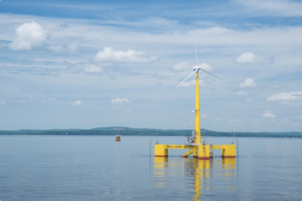
What is VolturnUS?
VolturnUS is the name of UMaine’s proprietary floating offshore wind turbine hull technology. The first platform to bear this name, VolturnUS 1:8, is a one-eighth scale, fully operating version of the full-scale concept. It is the first offshore wind turbine in the Americas. VolturnUS 1:8 was launched from Cianbro Corporation‘s facility in Brewer, Maine, on May 31, 2013, and operated off the coast of Castine, Maine, for 18 months.